|
Uttar Pradesh (Hindi: उत्तर प्रदेश, Urdu: اتر پردیش, pronounced [ˈʊtːər prəˈdeːʃ] ( listen), "Northern Province"), often referred to as U.P., is a state located in the northern part of India. With a population of over 190 million people,[1] it is India's most populous state, as well as the world's most populous sub-national entity. Were it a nation in its own right, Uttar Pradesh would be the world's sixth most populous country. Uttar Pradesh is the second largest state-economy in India contributing 8.17% to India's total GDP Between 2004 and 2009[citation needed].
With an area of 93,933 sq mi (243,290 km2), Uttar Pradesh covers a large part of the highly fertile and densely populated upper Gangetic plain. It shares an international border with Nepal to the north along with the Indian state of Uttarakhand, Himachal Pradesh to the north-west, Haryana, Delhi and Rajasthan on the west, Madhya Pradesh on the south, Chhattisgarh and Jharkhand on the south east and Bihar on the east. The administrative and legislative capital of Uttar Pradesh is Lucknow and the financial and industrial capital is Kanpur. The state's high court is based at Allahabad with a bench in state capital Lucknow. It is home to many historical cities, including Allahabad, Varanasi and Agra. Kanpur is its largest city; other big cities are Gorakhpur, Meerut, Agra, Aligarh, Bareilly, Ghaziabad and Noida.
Uttar Pradesh has an important place in the culture of India; it is considered to be the birthplace of Hinduism, has been the ancient seat of Hindu religion, learning and culture, and has many important sites of Hindu pilgrimage. The State also has several sites important to Buddhism: the Chaukhandi Stupa marks the spot where Buddha met his first disciples, while the Dhamek Stupa in Sarnath commemorates Buddha's first sermon. Also the town of Kushinagar is where Gautama Buddha died.
Throughout its history, the region of Uttar Pradesh was sometimes divided between smaller kingdoms and at other times formed an important part of larger empires that arose on its east or west, including the Magadha, Nanda, Mauryan, Sunga, Kushan, Gurjara, Gupta, Pala and Mughal empires.
The Indo-Gangetic plain, that spans most of the state, is also the birth place of the Indo-Islamic syncretic culture of the medieval period. It holds much of the heritage of the Mughal Empire, including the world famous mausoleum Taj Mahal built by Shah Jehan, the magnificent tomb of Mughal Emperor Akbar the Great in Agra and Akbar's capital-palace in Fatehpur Sikri. It was a centre of nationalism during the British colonial period and has continued to play a prominent role in Indian political and cultural movements. The state has a rich heritage of traditional crafts and cottage industries of various types that employ highly skilled craftsmen and artisans.
Hindus constitute 80% of the population in the state. Islam is practised by about 18% of the population while the remaining 2% include Atheists, Sikhs, Jains, Buddhists and Christians, and also the tribal population.
History
Evolution of the State
The area has undergone several name changes and territorial demarcations since the early 19th century, i.e., after the British East India Company had established its supremacy in the Gangetic plains. In 1833 the then Bengal Presidency of the Company was divided into two parts, one of which became Presidency of Agra; in 1836 the Agra area was named North-Western Provinces and placed under a Lieutenant Governor by the Company. In 1877, the two provinces of Agra and Oudh (Oudh was occupied by the Company, in 1858), were placed under one Colonial administrator of the British Crown; he was called Lieutenant Governor of the North-Western Provinces and Chief Commissioner of Oudh. In 1902 the name was changed to United Provinces of Agra and Oudh with Lieutenant Governor of the United Provinces of Agra and Oudh as administrator; in 1921 Lieutenant Governorship was elevated to Governorship and the name of the province was changed to United Provinces of British India. In 1935, the name was shortened to United Provinces. On independence from the British colonial rule in 1947, the princely states of Rampur, Banares and Tehri-Garwal were merged into the United Provinces. In 1950, the name of United Provinces was changed to Uttar Pradesh. In 1999 a separate Himalayan state, Uttaranchal, (now named Uttarakhand), was carved out of Uttar Pradesh.[edit] Prehistory, legends and ancient period
Archeological finds in Uttar Pradesh confirm presence of Stone Age homo sapiens hunter-gatherers in Chhatarpalia, Mahugarh, Parisdhia, Lalitpur, Nihi and Gopipur,[5][6][7][8] between 85±11 and 72±8 kyr (thousand years ago) before present (BP); Middle Paleolithic and later the Upper Paleolithic artifacts dated at 21–31 kyr BP;[9] Mesolithic/Microlithic hunter-gatherer's settlement, near Pratapgarh, around 10550–9550 CE;[10] villages, domesticated cattle, sheep or goats and evidence of plants and agriculture as early as 6000 CE – although, most dates range between c. 4000 and 1500 CE – thus initiating a sequence which extends into the Iron Age,[11][12][13] beginning from Indus Valley Civilization and Harappa Culture finds in the Saharanpur division through the Vedic period.
The ancient Mahajanapada era kingdom of Kosala in Ayodhya – where, according to Hindu legend, the divine king Rama of the Ramayana epic reigned – was located here. Krishna – another divine king of Hindu legend, who plays a key role in the Mahabharata epic and is revered as the eighth reincarnation (Avatara) of Hindu god Vishnu – was born in the city of Mathura. The aftermath of Mahabharata war is believed to have taken place in the area between the Doab region of Western Uttar Pradesh and Delhi, (in what was Kuru Mahajanapada), during the reign of the Pandava king Yudhishtira. The kingdom of the Kurus[14] corresponds to the Black and Red Ware and Painted Gray Ware culture and the beginning of the Iron Age in Northwestern India, around 1000 BCE. The revered Swaminarayan – mentioned in the Brahma Purana and Vishwaksena Samhita as the manifestation of God – was born in the village of Chhapaiya.
Most of the empire building invasions of North India, from the east as well as the west, passed through the vast swathe of Gangetic plains of what today is Uttar Pradesh. Control over this region was of vital importance to the power and stability of all of India's major empires, including the Mauryan (320–200 BCE), Kushan (100–250 CE) and Gupta (350–600 CE) Rajput (650–1036 CE) empires.
Perhaps no other historical monument has evoked as much awareness and admiration from tourists and travellers alike, as the magnificent Taj Mahal - fondly called by people as the ultimate requiem of love, from a great Mughal Emperor to his beloved.
So overwhelming is the exquisite beauty and presence of this marble mausoleum that centuries later today, even the very land where it has been located - Agra - has been immortalised as the City of the Taj. Yet, it doesn’t take much for the roving eye to discover that there's more to Agra than just the fabled Taj Mahal. The city is a virtual gateway to a world of discovery… a freeze-frame from a resplendant era that's long since gone by. In the great epic 'Mahabharat' the region of Agra is described as 'Agraban' (an integral part of the Brij Bhumi or the land of Lord Krishna). The latter part of Indian history outlines the origins of Agra to 1475 A.D., when the reign of Raja Badal Singh.
However, Agra came into limelight during the rule of Afghan King Sikandar Lodhi - who had made it the capital of his empire.Later in 1526 A.D., the Mughal Emperor Babar took upon himself the task for rendering Agra, a unique character and beauty of its own. The visionary that he was and a great patron of the arts, Emperor Babar brought in a change in the culture and life-style among the people of Agra, which then brought forth some of the finest craftsmen, artists, statesmen, warriors and nobility, this part of India had ever withnessed. The golden age of Agra's history, thus began to set in.
The next few hundred years of Agra witnessed the rise of the pomp and pageantry of three great Mughal monarchs - Emperor Akbar, Jehangir and ShahJahan - all of whom lavished on this fabled city, their love and riches immeasurable to transform the land into one of the great centers of art, culture, learning and commerce.
Much of the city's impressive past lives in evidence even today, in the hunting presence inside the monuments, the majesty of the buildings, the exquisite arts and crafts and not to forget, the lure of an exceptional cuisine… all, cherished as priceless legacies of a nostalgic past. The older city of Agra has impressively retained much of its resplendent history… captivating every visitor with fond memories to take back home. Today, luxury and modern convenience also exist adjacent to tradition - luxury hotels, shopping malls and plazas, wide avenues and a superb choice of venues for recreation, business, sports, pleasure, education and the arts.
Accessbiliey
Air
Kheria airport is 6 km from Agra town.
· Travel Corporation of India, Hotel Clarks Shiraz, 54, Taj Road, Tel : (0562) 2226521-22-23.
· Kinfisher Airlines, Hotel Clarks Shiraz, 54 Taj Road, Tel : (0562) 2226527 / Airport - 2400693
Rail Agra is connected to the major cities of India. Agra Cantt. Railway Station, Enquiries, Tel: 139. Reservation Tel: (0562) 2420998. Agra Fort Railway Station, Enquiries, Tel: 132. Reservation, Tel: (0562) 2464131 . Raja-ki-Mandi Railway Station, Enquiries, and Tel: 133 Reservation Tel: 2854477. Tundla Railway Station (26 km), Enquiries, Tel: 05612-229631.
Road
Agra is well-connected to the following cities by road: Mathura, Delhi, Chandigarh, Kanpur, Lucknow, Varanasi, Jhansi, Chitrakoot, etc. Agra's distance by road, from the main cities is as follows : Delhi 203 km, Khajuraho 393 km, Gwalior 118 km, Jaipur 237 km, Calcutta 1287 km, Varanasi 657 km, Mussoorie 417 km, Mumbai 1204 km.
· UPSRTC Bus Stand, Idgah, Enquiries, Tel : (0562) 2420324
· UPSRTC Bus Stand, Opp. Power House, Enquiries, Tel : (0562)2464557
· Rajasthan Roadways near Idgah Bus Stand (0562) -2420228
Local Transport
· Taxies: Air Conditioned/non air-conditioned taxis are available, without meter, at the railway stations, airport, hotels and at travel companies.
· Other transport: Un-metered auto-rickshaws, tongas and cycle rickshaws are available, rates of which are negotiable.
Places of intceresc A Glorious Heritage Taj Mahal
Taj Mahal was built by a grief stricken Emperor Shahjahan as a memorial to his beloved wife Mumtaz Mahal. A world-renowned wonder, Taj Mahal sits pretty on the north ern side of this green paradise. It looks the same from all the four sides! The Quranic inscriptions on its four entrances are carved in such subtle increase in size that may appear to be of the same size from top to bottom! Shahjahan invited master craftsmen from as far as Italy and Persia to help design his ambitious tribute to love.
The Taj Mahal is phenomenal not in the beauty alone that shines forth, but in the deep planning and design that went into its making, and the ethereal idea of immortalizing love. Delicate carvings in marble vie with gorgeous pietra dura for attention. Lapis-lazuli, Cornelian, Mother of pearl, Agate and Emerald are inlayed in floral and geometrical patterns in the marble itself. This enchanting mausoleum, on the bank of river Yamuna started in 1631 it took 22 years to complete with the help of an estimated 20000 workers.
Open: All days except FRIDAY
Timings: Sunrise to Sunset.
Distance: 9.7 Kms. (East gate)
Ph.: 2330498More about Taj Mahal
The Agra Fort
Ph.: 2960457
The great Mughal Emperor Akbar commissioned the construction of the Agra Fort in 1565, A.D. although additions were made till the time of his grandson Shahjahan.
The forbidding exteriors of this fort hide an inner paradise. There are a number of exquisite buildings like Moti Masjid - a white marble mosque akin to a perfect pearl; Diwan-I-Am, Diwan-I-Khaas, Musamman Burj - where Shahjahan died in 1666 A.D. Jahangir's Palace; Khaas Mahal and Shish Mahal.
Open: Sunrise to sunset.
Distance: 4.7 Kms.More about Agra Fort
Chini Ka Rauza
Mausoleum of Shahjahan's prime minister and Persian poet Afzal Khan Aalmi entitled "Maula Shukrullah, Shirazi" buit in 1635, exhibits fine use of glazed tiles. A certain raiser to an exotic Persian art style, which finds itself a home in Agra.
Open: Sunrise to sunset.
Distance: 11 Kms.
Taj Nature Walk
A beautiful natural forest cover spread over 70 hectares of area just 500 mts away from the eastern gate of Taj Mahal . An excellent view of the Taj can be found from the different mounds of the park. Flora & Funa of different species are found here.
Distance: 9.5 kms.
SAMADH OF SOAMIJI MAHARAJ 
It is a tribute to the founder of Radha Swami faith. Devout followers believe the service, purifies the soul. At soamibagh their services bears fruit in an edifice as spectacular as the Taj Built in white and colour marble, it is continuously being decorated for more than 100 years now with extra-ordinary feast in stone and gems.
Distance: 10 Kms.
RAM BAGH
One of the earliest Mughal gardens, believed to be laid out by Mughal Emperor Babur, the founder of Mughal dynasty. It is said that Babur was temporarily buried here before being taken to Kabul in Afganistan.
Open: Sunrise to sunset. Distance -11 Km
Distance: 9.2 Kms.
MEHTAB BAGH
Mehtab Bagh is located on the left bank of river Yamuna opposite to the Taj Mahal. The garden complex is a huge square measuring approximately 300m X 300m and in straight alignment with the Taj Mahal. The excavation has revealed a huge octagonal tank on the southern periphery : baradaris or pavilion on the east and west: a small octagonal tank at the center and a gateway at the northern wall.
Distance: 14 Kms.
Open : Sunrise to sunset.
ITIMAD-UD-DAULA'S: (Baby Taj)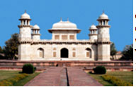
Tel: 2280030
This exquisite marble tomb was made by Emperor Jahangir’s queen, Nurjahan , in the memory of her father Mirza Ghias Beg during 1622-1628 A.D. Built entirely in white marble and inlaid with semi-precious stones, their mausoleum on the bank of the Yamuna River, exhibits a strong Persian influence. Distance-11Km
Open: Sunrise to sunset.
SIKANDRA
Tel: 2641230
It is the mausoleum of Emperor Akbar. It represents his philosophy and secular outlook, combining the best of Hindu and Muslim architectures in a superlative fusion. Completed in 1613 A.D., it is one of the well preserved monument.
Distance: 13.7 Kms.
Open: Sunrise to sunset. 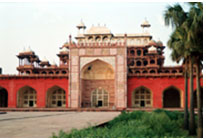
MARIYAM’S TOMB
This unique tomb in red sandstone was built in memory of Emperor Akbar’s wife Mariyam Zamani. The tomb has some exceptional carvings.
Distance: 14.5 Kms.
Open: Sunrise to sunset.
JAMA MASJID
The building with rectangular open forecourt was constructed in 1648A.D. by Shahajahan’s daughter, Jehanara Begum of particular importance is its wonderful assimilation of Iranian architecture.
Distance: 7 Kms
Open: Sunrise to sunset.
TEMPLES
Mankameshwar Mandir, Rawli, Balkeshwar Mandir, Prithvinath Mandir, Rajeshwar Mandir , kailash Mandir, Renuka Dham (Shanidev Tample).
BAUDDHMATH Buddha Bihar, Agra Fort Bus stand (Monastery)
GURUDWARAS Guru ka Tal Gurudwara, Sikandra Mathura Road, Maithan Gurudwara, Fulatti Hathighat Gurudwara,
CHURCHES Cathedral St. Peter's, St. Patricks, Baptist Church, Sai Ka Takia, Catholic Church,Sadar Bazar
MOSQUES Jama Masjid near Bijlighar, Taj Mahal, Shaikh Salim Chisti Dargah, Fatehpur Sikri
JAIN TEMPLES Digambar Jain temple, Taj Ganj, Tirthadham, Mangalayatan, Sasni, Aligarh, Chintamani Parshwanath, Roshan Mohalla, Dadabari, Shahganj.
Mathura in Uttar Pradesh served as the capital of the Kushan Empire.Following the Hun invasions that broke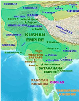 Guptas' empire, the Ganges-Yamuna Doab saw the rise of Kannauj. During the reign of Harshavardhana (590–647 CE), the Kannauj empire was at its zenith; spanning from Punjab and Gujarat to Bengal and Orissa – and parts of central India, north of the Narmada River – it encompassed the entire Indo-Gangetic plain. A patron of Buddhism and the University at Nalanda, Harsha organized theological debates and also patronised art and literature. A noted author on his own merit, he wrote three Sanskrit plays. Many communities in various parts of India boast of being descendants of migrants from Kannauj, reflecting its glory in the past.[15] Soon after Harshavardhana's death, his empire disintegrated into many kingdoms, to be invaded and ruled mostly by Rajputs, who also challenged Bengal's mighty Pala Empire's control of the region. Guptas' empire, the Ganges-Yamuna Doab saw the rise of Kannauj. During the reign of Harshavardhana (590–647 CE), the Kannauj empire was at its zenith; spanning from Punjab and Gujarat to Bengal and Orissa – and parts of central India, north of the Narmada River – it encompassed the entire Indo-Gangetic plain. A patron of Buddhism and the University at Nalanda, Harsha organized theological debates and also patronised art and literature. A noted author on his own merit, he wrote three Sanskrit plays. Many communities in various parts of India boast of being descendants of migrants from Kannauj, reflecting its glory in the past.[15] Soon after Harshavardhana's death, his empire disintegrated into many kingdoms, to be invaded and ruled mostly by Rajputs, who also challenged Bengal's mighty Pala Empire's control of the region.
Medieval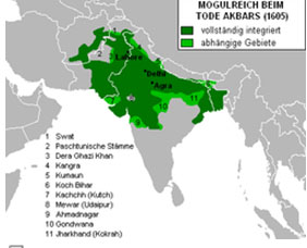
Agra and Fatehpur Sikri in Uttar Pradesh were the capital cities of Akbar the Great.
The fall of the post-Harshavardhana Rajput kings of north India came when the Turko-Afghan Muslim rulers moved into present day Uttar Pradesh. Much of the state formed part of the various Indo-Islamic empires (Sultanates) after 1000 CE and was ruled from their capital, Delhi.
Later, in Mughal times, U.P. became the heartland of their vast empire; they called the place 'Hindustan', which is used to this day as the name for India in several languages. Agra and Fatehpur Sikri were the capital cities of Akbar, the great Mughal Emperor of India. At their zenith, during the rule of Aurangzeb, the Mughal Empire covered almost the entire Indian subcontinent (including present day Afghanistan, Pakistan and Bangladesh), which was ruled at different times from Delhi, Agra and Allahabad.
When the Mughal Empire disintegrated, their last territory remained confined to the Doab region of Hindustan and Delhi. Other areas of Hindustan (U.P.) were now ruled by different rulers: Oudh was ruled by the Nawabs of Oudh, Rohilkhand by Afghans, Bundelkhand by the Marathas and Benaras by its own king, while Nepal controlled Kumaon-Garhwal as a part of Greater Nepal. The state's capital city of Lucknow was established by the Muslim Nawabs of Oudh in the 18th century.
Modern-colonial
Starting from Bengal in the later half of the 18th century, a series of battles for North Indian lands finally gave the British  East India Company accession over this state's territories – including the territories of Bundelkhand, Kumaon and Benaras rulers – and the last Mughal territories of Doab and Delhi. When the Company included Ajmer and Jaipur kingdoms in this northern territory, they named it the "North-Western Provinces" (of Agra). Today, the area may seem large compared to several of the Republic of India's present 'mini-states' – no more than the size of earlier 'divisions' of the British era – but at the time it was one of the smallest British provinces. Its capital shifted twice between Agra and Allahabad East India Company accession over this state's territories – including the territories of Bundelkhand, Kumaon and Benaras rulers – and the last Mughal territories of Doab and Delhi. When the Company included Ajmer and Jaipur kingdoms in this northern territory, they named it the "North-Western Provinces" (of Agra). Today, the area may seem large compared to several of the Republic of India's present 'mini-states' – no more than the size of earlier 'divisions' of the British era – but at the time it was one of the smallest British provinces. Its capital shifted twice between Agra and Allahabad
Mangal Pandey
Due to dissatisfaction with British rule, a serious rebellion erupted in various parts of North India; Meerut cantonment's sepoy, Mangal Pandey, is widely credited as its starting point. It came to be known as the Indian Rebellion of 1857. After the revolt failed the British attempted to divide the most rebellious regions by reorganizing the administrative boundaries of the region, splitting the Delhi region from ‘NWFP of Agra’ and merging it with Punjab, while the Ajmer- Marwar region was merged with Rajputana and Oudh was incorporated into the state. The new state was called the 'North Western Provinces of Agra and Oudh', which in 1902 was renamed as the United Provinces of Agra and Oudh. It was commonly referred to as the United Provinces or its acronym UP.
United Provinces of Agra and Oudh in 1903In 1920, the capital of the province was shifted from Allahabad to Lucknow. The high court continued to be at Allahabad, but a bench was established at Lucknow. Allahabad continues to be an important administrative base of today's Uttar Pradesh and has several administrative headquarters.
Uttar Pradesh continued to be central to Indian politics and was especially important in modern Indian history as a hotbed of both the Indian Independence Movement and the Pakistan Movement. Nationally known figures such as Jawaharlal Nehru were among the leaders of the movement in UP. The All India Kisan Sabha (AIKS) was formed at the Lucknow session of the Indian National Congress on 11 April 1936 with the legendary nationalist Swami Sahajanand Saraswati elected as its first President,[16] in order to address the long standing grievances of the peasantry and mobilise them against the zamindari landlords' attacks on their occupancy rights, thus sparking the Farmers' movement in India.[17][18]
During the Quit India Movement of 1942, Ballia district overthrew the colonial authority and installed an independent administration under Chittu Pandey. Ballia became known then as Baghi Ballia (Rebel Ballia) for this significant contribution in India's freedom struggle.
Post-independence
After independence, the state was renamed Uttar Pradesh ("northern province") by its first chief minister, Govind Ballabh Pant. Pant was well acquainted with and close to Jawaharlal Nehru (the first Prime Minister of free India) and was also popular in the Congress Party. He established such a good reputation in Lucknow that Nehru called him to Delhi, the capital and seat of Central Government of the country, to make him Home Minister of India in 27 December 1954. He was succeeded by Dr. Sampoornanand, a classicist Sanskrit scholar. Following a political crisis in Uttar Pradesh, initiated by Kamlapati Tripathi and C.B.Gupta, Sampurnanand was asked to resign as CM in 1960 and sent to Rajasthan as the Governor of Rajasthan, paving the way for Gupta and Tripathi to become Chief Ministers.
Sucheta Kripalani served as India's first woman chief minister from October 1963 until March 1967, when a two-month long strike by state employees caused her to step down. After her, Chandra Bhanu Gupta assumed the office of Chief Minister with Laxmi Raman Acharya as Finance Minister, but the government lasted for only two years due to the confusion and chaos which ended only with the defection of Charan Singh from the Congress with a small set of legislators. He set up a party called the Jana Congress, which formed the first non-Congress government in U.P. and ruled for over a year.
Hemvati Nandan Bahuguna was chief minister for Congress Party government for part of the 1970s. He was dismissed by the Central Government headed by Indira Gandhi, along with several other non-Congress chief ministers, shortly after the imposition of the widely unpopular Emergency, when Narain Dutt Tewari – later chief minister of Uttarakhand – became chief minister. The Congress Party lost heavily in 1977 elections, following the lifting of the Emergency, but romped back to power in 1980, when Mrs. Gandhi handpicked the man who would later become her son's principal opposition, V.P. Singh, to become Chief Minister.
[edit] Creation of the state of Uttarakhand
On 9 November 2000, the Himalayan portion of the state, comprising the Garhwal and Kumaon divisions and Haridwar district, was formed into a new state 'Uttaranchal', now called Uttarakhand, meaning the 'Northern Segment' state.
[edit] Geography
Main article: Geography of Uttar Pradesh
Uttar Pradesh shares an international border with Nepal and is bounded by the Indian states of Uttarakhand, Himachal Pradesh, Haryana, Delhi, Rajasthan, Madhya Pradesh, Chhattisgarh, Jharkhand and Bihar. The state can be divided into two distinct hypsographical regions.
The larger Gangetic Plain region is in the north: it includes the Ganges-Yamuna Doab, the Ghaghra plains, the Ganges plains and the Terai. It has highly fertile alluvial soils and flat topography (slope 2 m/km) broken by numerous ponds, lakes and rivers.
The smaller Vindhya Hills and Plateau region is in the south: it is characterised by hard rock strata and varied topography of hills, plains, valleys and plateau; limited availability of water makes the region relatively arid.
[edit] Flora and fauna
Uttar Pradesh has 12.8% land under forest cover now. In spite of alarming deforestation and poaching of wild life, a diverse flora and fauna exists. Several species of trees, large and small mammals, reptiles and insects are found in the belt of temperate upper mountainous forests; medicinal plants are also found wild here, or are now grown on plantations. Terai-Duar savanna and grasslands support cattle. Moist deciduous trees grow in the upper Gangetic plain, including its riverbanks. In fact, this vast plain is so fertile and life supporting that any thing, which can live or grow anywhere, will do so here. Ganges and its tributaries are the habitat of a variety of large and small reptiles, amphibians, fresh-water fish and crabs. Mostly scrubs, trees like babool and animals like chinkara are found in the arid Vindhyas.[19][20] The state’s important plants and animals include the following:
Trees: pine, rhododendrons, silver fir, deodar, saal, oak, teak, sheesham, mango, neem, banyan, peepal, imli, jamun, mahua, semal, gular and dhak.
Medicinal plants: hingan,[21] Dhak,[22] rauwolfia, sepentina, hexandrum, podophyllum.
Large vertebrates: elephant, tiger, bear, neelgai, wild pig, deer, wolf, jackal, fox, languor, porcupine.
Birds: peacock, gray quail, pigeon, swallow, maina, Indian parakeet, crow and duck.
Reptiles: crocodile, gharial, goh, snakes, chameleon and other lizards.
Fish: Rohu, catla, khusa, parhan, patra, moi, korouch and singhi.
According to Hindu legend, Lord Rama’s warrior devotee Hanuman had brought life saving Sanjivani herbs from a mountain of this, or possibly the breakaway Uttarakhand, region.
[edit] Climate
The climate of Uttar Pradesh is predominantly subtropical, but weather conditions change significantly with location and seasons:
Temperature: Depending on the elevation, the average temperatures vary from 12.5–17.5 °C (55–64 °F) in January to 27.5–32.5 °C (82–91 °F) in May and June. The highest temperature recorded in the State was 49.9 °C (121.8 °F) at Gonda on 8 May 1958.
Rainfall: Rainfall in the State ranges from 1,000–2,000 mm (39–79 in) in the east to 600–1,000 mm (24–39 in) in the west. About 90% of the rainfall occurs during the southwest Monsoon, lasting from about June to September. With most of the rainfall concentrated during this four-month period, floods are a recurring problem and cause heavy damage to crops, life, and property, particularly in the eastern part of the state, where the Himalayan-origin rivers flow with a very low north-south gradient.
Snowfall: In the Himalayan region of the State, annual snowfall averaging 3 to 5 metres (10 to 15 feet) is common between December and March.
Droughts: Periodic failure of monsoons results in drought conditions and crop failure.

Perched atop a rocky ridge 37 km west of Agra, Fatehpur Sikri came into being four centuries ago when the Emperor Akbar, not yet 28 years old, created the first planned city in Indo-Islamic style. The city was actualised with great energy, but was completely abandoned a little more than a decade later.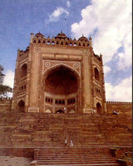
In 1568, Akbar was secure and powerful but he had no son and heir. His search for blessing for the birth of a successor brought him to the Sufi mystic Shaikh Salim Chisti, who lived in Sikri village. The saint prophesied the birth of three sons and soon after was born Prince Salim, later to become Emperor Jahangir. In gratitude for the blessing Akbar decided to create imperial residences in Sikri, which would function as a joint capital with Agra. As a mark of his faith and his recent victories, he named his new city Fatehpur Sikri. Akbar was a keen builder and the plan of Fatehpur Sikri reveals an architectural mastermind at work. Research has proved that it was planned on a definite mathematical grid.
The siting of the Jama Masjid marked the actual beginning of the city which came up around it. The palace courts were laid out parallel to the cardinally aligned mosque and the sequential order of the palaces were emphasised by change in level. The most public space was at the lowest level, while the royal harem was at the highest.
Fatehpur Sikri is built in red sandstone, and is a beautiful blend of Hindu and Islamic architectural elements. The sandstone is richly ornamented with carving and fretwork. Fatehpur Sikri was abandoned 14 years after its creation. A shortage of water is believed to be the reason. Today it is a ghost city, its architecture is in a perfect state of preservation, and wandering through the palaces it is easy to imagine that this was once a royal residence and a dynamic cultural centre.
• Area : 8.0 Sq. km.
• Population : 28804 (2001 census)
• Altitude : 194 meters above sea level. 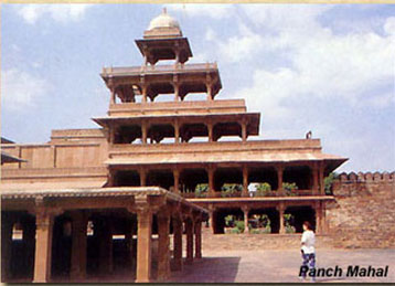
• Season : October-March
• Clothing (Summer) : Cotton (Winter) : Light Woolen
• Language : Hindi, English and Urdu
• Local Transport : Buses, Cycle-rickshaws, Tonga's/ Taxis.
• STD Code : 05613
Air
Kheria Airport at Agra – 40 km.RailAgra Cantt Railway Station 40 km (see Agra for rail connections)Road
Fatehpur Sikri is connected to Agra and neighbouring centres by regular bus services of UPSRTC. Some of the major road distances are:
•Bharatpur – 25 km.
•Jaipur – 225 km.
Diwan-I-Am
The first enclosure of the palace is a vast courtyard in which the emperor gave daily public audience and dispensed justice.
Diwan-I-Khas
The Diwan-I-Am gave access to the second enclosure, a large quadrangle which contained all the major functions of the palace, and the finest buildings of Fatehpur Sikri. At the northern end is the Diwan-I-Khas. Also referred to as the Hall of Private Audiences, it is an astonishing chamber dominated by a massive carved pillar, which supports a fantastic capital above which is a balcony.
Pachisi Court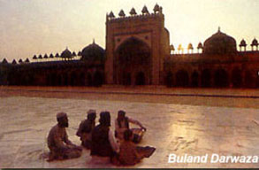
The paving of this courtyard is laid out to resemble the cruciform board on which the game Pachisi is played. It is believed that Akbar used live pieces for the game.
Hallowed by the aura of Shri Krishna
Brajbhoomi - the land where Lord Krishna was born and spent his youth, has today little towns and hamlets that are still alive with the Krishna- legend and still redolent with the music of his flute. Mathura, a quiet town on the River Yamuna was transformed into a place of faith after Lord Krishna was born here. Vrindavan, a village - once noted for its fragrant groves, is where he spent an eventful youth. There are numerous other little spots in the area that still reverberate with the enchantment of Lord Krishna.
The city of Mathura, in Uttar Pradesh, the nucleus of Brajbhoomi, is located at a distances of 145 km south- east of Delhi and 58 km north-west of Agra. Covering an area of about 3,800 sq. km. today, Brajbhoomi can be divided into two distinct units - the eastern part in the trans-Yamuna tract with places like Gokul, Mahavan, Baldeo, Mat and Bajna and the western side of the Yamuna covering the Mathura region that encompasses Vrindavan, Govardhan, Kusum Sarovar, Barsana and Nandgaon .
The land of Braj starts from Kotban near Hodel about 95 km from Delhi and ends at Runakta which is known specially for its association with the great poet Surdas, an ardent Krishna devotee.
The embodiment of love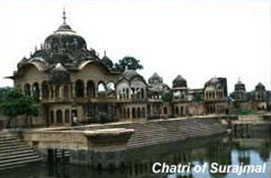
Revered as the most endearing of the Hindu gods, Shri Krishna is fondly remembered for his charm, his mischievous pranks and his extraordinary exploits. As the charioteer and preceptor to Arjun in the famous battle of Kurukshetra, he revealed to the world the supreme truths of life. Shri Krishna, an incarnation of Lord Vishnu, was born in the Dwapara Yuga as the eighth son of the Yadava prince Vasudev and his wife Devaki. To save him from his maternal uncle Kansa wrath, the infant Krishna was spirited away soon after birth to Gokul, the village of the gopas (cowherds) in Braj. It was here that he grew to manhood, in the tender care of his foster parents Nand and Yashoda in the happy company of the cowherds.
Mathura
A long line of picturesque ghats - with their steps leading to the water's edge, arched gateways and temple spires extending along the right bank of the River Yamuna, emphasis the sacred character of the town of Mathura. The birth place of Lord Krishna, "the best known, best loved and most complex of Lord Vishnu's manifestations" - Mathura is today an important place of pilgrimage. The city stretches along the right bank of the Yamuna and the continuous line of ghats along the river makes a splendid spectacle when viewed from the opposite bank.
Today, Mathura is a city of temples and shrines abustle with the thousands of devotees who come to visit the city of Lord Krishna. A splendid temple at the Katra Keshav Dev marks the spot that is believed to be the Shri Krishna Janmasthan - the birthplace of the Lord, by his devotees. Another beautiful shrine, the Gita Mandir, located on the Mathura -Vrindavan Road has a fine image of Shri Krishna in its sanctum. The whole of the Bhagwad Gita is inscribed on the walls of this temple.
The most popular shrine at Mathura is the Dwarikadhish Temple to the north of the town, dedicated to Shri Krishna. This was built in 1815 by a staunch and wealthy devotee, Seth Gokuldas Parikh, Treasurer of the State of Gwalior.
There are about 25 ghats in Mathura today, of which the most important is the Vishram Ghat. Where according to legend, Shri Krishna took his rest after killing Kansa.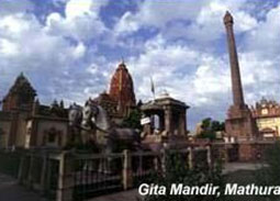
It is at Vishram Ghat that the traditional parikrama (circumbulation of all the important religious and cultural places of the city) starts and ends. The 12 ghats to the north of Vishram Ghat include the Ganesh Ghat, Dashashwamedh Ghat with its Neelakantheshwar Temple, Saraswati Sangam Ghat, Chakratirtha Ghat, Krishnaganga Ghat, Somatirth or Swami Ghat, Ghantagharan Ghat, Dharapattan Ghat, Vaikuntha Ghat, Navtirtha or Varahkshetra Ghat, Asikunda ghat and Manikarnika Ghat. To the south, there are 11 ghats - the Guptatirth Ghat, Prayag Ghat marked by the Veni Madhav Temple, Shyam Ghat, Ram Ghat, Kankhal Ghat, the site of the Janmashtami and Jhula festivals, Dhruva ghat, Saptrishi Ghat, Mokshatirth Ghat, Surya Ghat, Ravan Koti Ghat and Buddha Ghat.
The Vishram Ghat is lined with elegant temples and some of Mathura's most important shrines are found here - the Mukut Temple, Radha-Damodar, Murli Manohar, Neelkantheshwar, Yamuna-Krishna, Langali Hanuman and Narasimha temples. The baithak of the great Vaishnava Saint, Shri Chaitanya, is also near by.
The aarti held at the Vishram Ghat each evening is not to be missed, for the little oil lamps that are floated on the river set the placid water as sparkle with a myriad flickering lights.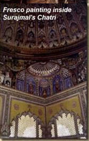
No pilgrimage to Mathura is complete without a visit to its kunds. Tradition has it that there were 159 ancient kunds in all. Of these only four survive and can be seen. There is the elegant shiv Tal, the more famous Potara Kund associated closely with Lord Krishna besides the Balbhadra and Saraswati kunds.
The town has a number of Shaivite temples as well. The chief among them being the Bhuteshwar Mahadev Temple to the west of the town, the Gokarneshwar Temple in the north, the Rangeshwar. Mahadev Temple to the south and the Pipaleshwar Mahadev Temple to the east.
on the northern bank of the River Yamuna is the Kans Qila, now mostly in
ruins. An observatory, akin to the Jantar Mantar at Delhi, was built here at a later date by Maharaja Sawai Jai Singh (1699-1743) of Amer.
Sati Burj, 17 mt. high, built of red sandstone in 1570 AD, is a slim tower which commemorates the death of a noble lady - widow of Raja Bihari Mal of Amer who committed sati. The four storeyed tower was erected by Raja Bhagwan Das on the right bank of the Yamuna at Sati Ghat
The Jama Masjid with its four lofty minarets and bright mosaic, built in 1661 AD, is also a must see.
The Government Museum, Mathura originally founded by F.S. Growse in 1874, is today one of the leading centres for research, study and the preservation of Mathura' s splendid heritage of art. The museum housed in a fine octagonal, red sandstone building, located at Dampier Park, has the largest collection of Kushana sculptures in the country.
The Museum has also fine collections of stone sculpture and terracotta, gold, silver and copper coins, clay seals, ancient pottery, paintings and bronzes.
For more information contact:
•Director, Government Museum, Dampier Park, Mathura, Ph : (0565)2403191
Museum visiting hours : 1st July to 30th April: 10.30 AM to 4.30 PM, 1st May to 30th June : 7.30 AM to 12.30 PMClosed on Monday, and every second Sunday of every month and other Govt. gazetted holidays.
•Area : 3,780 sq. km. (Mathura District)
•Population (urban) : 20, 74, 516 (2001 census)
•Altitude above sea level : 187 metres
•Area : 3,780 sq. km. (Mathura District)
•Population (urban) : 20, 74, 516 (2001 census)
•Altitude above sea level : 187 metres
|
Season |
Max |
Min |
|
Summer |
4500C |
220C |
|
Winter |
320 C |
140 C | •Rainfall : 65 cms (June to September)
•Clothing : Summer - Cottons
•Winter - Light woollens
•Languages : Hindi, Brajbhasha and English
Rail
Mathura is on the main lines of the Central and Western Railways and is connected with all the important cities of the state and country such as Delhi, Agra, Mumbai, Jaipur, Gwalior, Calcutta, Hydrabad, Chennai, Lucknow etc.
Mathura Junction, North Central Railway (Enquiry Nos. - 131,132, 133, 135)
Mathura Canntt., North Eastern Railway (Enquiry - 2408131)
Road
Mathura is connected to all the major cities, by National Highways. It is linked by the regular state bus services of Uttar Pradesh, Madhya Pradesh, Rajasthan and Haryana
Bhooteshwar Bus Station Mathura, Ph : 2460232
Old Bus Station, Ph : 2406468
Local Transport:
Private buses, Tempos, Rickshaws, Cycle Rickshaws and Tongas are also available.
•Hotel Madhuvan, Krishna Nagar, Ph : (0565)2420064,2420058, Fax : 2420684
•Best Western Radha Ashok, Masani By Pass Road, Chhatikara, Ph : (0565)2420064, Fax : 2420084.
•Hotel Mansarovar Palace, State Bank Crossing, Ph : (0565)2408686, 2406525. Fax : (0565)2401611.
•Agra Hotel, Bengali Ghat Ph : 2403318
•Dwapar Resorts, 162 milestone, NH-2, Delhi-Agra Road, Ph : 2842103, 2842092
•Hotel Megh Raj, Roshan Bazar, Tilak Dwar, Ph : (0565)2406162
•Modern Hotel, Opp Old Bus Stand, Ph : (0565)2404747
•Hotel Braj Vihar, Tilak Bazar, Ph : (0565)2404209
•Hotel Raj Mahal, Agra Road, Holi Gate, Ph : (0565)2406598
•Hotel Sanjay Palace, Arya Samaj Road, Holi Gate, Ph : (0565)2407867
•Hotel Surya International, Near Bus Stand, Station Road, Ph : (0565)2409344
•Mangalam Tourist Lodge, Dampier Nagar, Ph : (0565)2405965
•Hotel Satyam, Masani Road, Near Janam Bhumi, Ph : (0565)2406767
•International Guest House, Krishna Janam Bhumi, Ph : (0565)2423888
•Rukmani Cottage, Dwarikadhish Temple, Ph : (0565)2404200
•Orphic Resorts Country Inn, Kosi Kalan (Mathura) Ph : 05662-234801-8, Fax : 05662-232945
•UPSTDC, Hotel Kadamb, Civil Lines, Ph : (0565)2407822
•Hotel Krishna, Station Road, Ph : 2409787
•Hotel Brajvasi Royal, State bank Chauraha, Ph : 2401224-6, Fax : 2401227
•Hotel Sheetal Regency, Masani Road, Ph : 2410316, 2410326
•Hotel Sheel Gopal Vizon, Station Road, Ph : 3011095
•Hotel Abhinandan, Govardhan Chauraha, Ph : 2423213, 2422290
•Hotel Radha Ashok, Masani Bypass, Ph : 2530394-6
•Hotel Duke Palace, Masani Bypass, Ph : 2430353
•Hotel Govardhan Palace, Ph : NH-2 Opposite Narholi Thana, Ph : 2409917-19
•Hotel Vrindavan Country Club, 106 Km. Stone Azizpur Kosikala, Ph : 05662-234671, 233058
•Kosi Tourist Complex, Kosikala, Ph : 05662-232314
•Rahi Tourist House, Civil Lines, Ph : 2407822
•Hotel Sanjay Royal, Station Road, Ph : 2413655
•Hotel Braj Dham, Station Road, Ph : 9359502628
•McDonald, Delhi-Agra Bypass
•Status, Hotel Brajwasi Royal
•Gokul Restaurant - 0565-2530310, By Pass, Mathura
•Madankala Restaurant, Hotel Sheel Gopalan Vizin, Mathura
•Shobhit Toor & Travels, Gali Banke Bihari Dusayat, Vrindavan, Ph : 941220618, 9219882777, 5521361, 2442431
•Braj Vihar Travels, Tilak Dwar, Ph : 2502323, 2501159, 2403364
•Agarwal Travel Agency, Tilak Dwar, Ph : 2501734, 2501986
•Alpa Inn Travels & tours, Vikas bazar, Ph : 2409411, Fax : 2400844
•Braj Darshan Travels, Tilak Dwar, Ph : 2500911
Post Offices
•Main Post Office, Civil Lines, Ph : 2403014
•City Post Office, Ph : 2501602
•Sri Krishna Janmasthan Post Office, Ph : 2423848
•Krishna Nagar Post Office, Ph : 2420146
Banks
•State Bank of India, Ph : 2501398, 2505770 (ATM - Main Branch, Highway Palace, Sri Krishna Janmasthan, Civil Lines, Refinery, Vrindavan)
•Punjab National Bank, Ph : 2505935, 2505938 (ATM - Raman Reti Marg Vrindavan)
•Allahabad bank, Ph : 2501547, 2500705
•Bank of Baroda, Ph : 2505969, 2403694 (ATM - Main Branch)
•Central Bank, Ph : 2406023, 2403726
•Syndicate Bank, Ph : 2406023
•Union Bank, Ph : 2502626, 2401621
•Oriental Bank of Commerce, Ph : 2500372, 2504328 (ATM - Highway Plaza, DD plaza, Aurangabad)
•HDFC, Ph : 2463805-7 (ATM - Bhooteshwar Marg)
•ICICI, Ph : 2413966/67 (ATM - Bhooteshwar Marg)
Mathura, the land of cows, is famed for its milk based sweetmeats. A variety of mouth watering savouries are also well known specialties of the town.
The little town comes alive with colourful festivals throughout the year. The Rang Gulal Mahotsav, held annually, celebrates Holi in an exuberant fashion. During the festival of colour which heralds the onset of spring. Several classical and folk artistes render enthralling performances.
Janmashtami, the birthday of Shri Krishna is celebrated with great pomp and splendour throughout Braj. The Raaslila is enacted recreating the many legends of Shri Krishna's life - his exploits and his amorous dalliances with the gopies. Ceremonies in the temples at midnight include the bathing of the image of infant Krishna which is then placed in a silver cradle. Songs of devotion are sung and toys offered for the amusement of the divine child. Thousands gather to offer their prayers and Mathura is astir with their devotion and celebrations.
The important fairs and festivals of the town include :
|
Rath-ka-Mela |
Vrindavan |
March |
|
Guru Purnima
(Muria Puno) |
Govardhan |
July |
|
Hariyali Teej |
Braj Mandal |
July |
|
Janmashtami |
Braj Mandal |
August/September |
|
Radha Ashtami |
Barsana, Gokul |
August |
|
Annakut |
Goverdhan, Mathura |
Sept./Oct. |
|
Yam Dwitiya |
Vishram Ghat |
Sept./Oct. |
|
Kansa Vadh |
|
Sept. |
|
Holi |
Braj Mandal |
Feb./Mar. |
|
Latthmar Holi |
Nandgaon |
Feb./Mar. (Phalguna Shukla 9 & 10) |
Braj Parikrama
The Rainy month of Bhadon, the month when the Lord Krishna was born, is a time of colourful celebrations. The famous Braj Parikrama - a pilgrimage of all the places in Braj that associated with Shri Krishna, is undertaken. Traditionally, the Chaurasi kos (84 kos) pilgrimage of Braj Mandal, with its 12 vanas (forests). 24 upvanas (groves), sacred hill Govardhan, divine River Yamuna and numerous holy places along its banks, is undertaken annually by lakhs of devotees from all over the country.
The Yatra extends to Kotban to the north of Mathura, to Nandgaon, Barsana and the Govardhan Hill to the west and South-west of the city and to the a banks of the Yamuna to the east, where the Baldeo Temple is located. Colourful melas and performances of the Raaslila (a depiction of the exploits of Shri Krishna) are distinctive to this festive period.
Gokul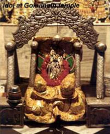
The most celebrated of Shri Krishna's abode, Gokul lies to the west of Sadabad, 1.6 km from Mahavan and 15 km south-east of Mathura, on the Mathura - Etah metalled road. It was here that Lord Krishna was brought up in secrecy by Yashoda, in the pastoral beauty of this village on the banks of the Yamuna.
Gokul attained importance during the time of Vallabhacharya (1479-1531) when it became a major centre of the Bhakti cult. The three oldest temples in the place are those dedicated to Gokulnath, Madan Mohan and Vitthalnath, said to have been built around
1511. The other temples include those of Dwarika Nath and Balkrishna in the shrines which were built in the honour of Lord Mahadeo in 1602 by Raja Vijai Singh of Jodhpur.
The celebration of Janmashtami in August is unparalleled for its gaiety and melas are constant attraction here. Other festivities celebrated with traditional fervour include the Janmotsav in Bhadon, the Annakut festival and Trinavat Mela held on the fourth day of the dark half of Kartik month.
Important sites worth visiting in Gokul include the Gokulnath Temple, Raja Thakur Temple, Gopal Lalji Temple and the Morwala Temple.
•Population: 4,021 (2001 census)
Mahavan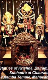
Around 18 km from Mathura, lying on the left bank of the River Yamuna, is the large shrine of Mathuranath. It is famed for its Chaurasi Khambha (eighty four pillars). The palace of Rohini, the mother of Baldeo is now the Chhathi-Palana Temple. Other important shrines include, the Shymlalji Temple, the Yogmaya Temple, Tranairatri Temple and the Mahamall Rai Ji's palace.
•Population: 8,576 (2001 census)
Baldeo
Baldeo is 20 km south-east of Mathura and 8.5 km south - east of Mahavan on the road to Sadabad. It derives its name from the famous temple dedicated to Balram, the elder brother of Lord Krishna. It was built by Shyam Das of Delhi 200 years ago. The main image in the sanctum is that the Baldeo or Balram with his spouse Revati. Near by is the brick lined tank, the Khir Sagar or Balbhadra Kund, from where the original image housed in the temple was found.
• opulation: 9,684 (2001 census)
Govardhan
Govardhan is situated 26 km west of Mathura on the state highway to Deeg. A famous place of Hindu pilgrimage, Govardhan is located on a narrow sandstone hill known as Giriraj which is about 8 km in length. The young Lord Krishna is said to have held Giriraj up on the tip of a finger for 7 days and nights to shield the people of Braj from the deluge of rain sent down by Lord Indra.
Govardhan is set along the edge of a large masonry tank known as the Mansi Ganga, which is believed to have been brought into existence by the operation of the divine will. Its enclosures were built by Raja Bhagwan Das of Amer in 1637 and embellished by Raja Man Singh, who built a long flight of steps leading up, from the end of the tank. Close by is the famous red sandstone temple of Haridev and the Kusum Sarovar with exquisitely carved chhatris - the cenotaphs of the members of the royal family of Bharatpur, who perished whilst fighting against the British in 1825. Towards the south is the beautiful chhatri of Raja Surajmal of Bharatpur. Fine frescoes - illuminating the life of Surajmal, vividly depict darbar and hunting scenes, royal processions and wars.
•Population : 18,494 (2001 census)
•Barsana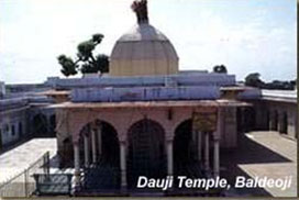
Barsana, 50 km to the north-west of Mathura and 19 km north-west of Govardhan, is situated at the foot of a hill that is named after Brahma. Barsana was once the home of Radha-Rani, Krishna's beloved and consort.
Temples dedicated to the divine couple ornament the four elevations of the hill. The main among them is the Radha-Rani Temple, more fondly referred to as the Ladliji Temple. The most beautiful temple at Barsana, it was built by Raja Bir Singh Ju Deo of Orchha in 1675. The new marble temple adjoining it is a later addition. The other three shrines are the Man Mandir, Dargah and Mor-Kutir temples. The area between the hill housing the Radha-Rani Temple and the adjoining one, is known as the Sankari-Khor. This is the venue of the annual fair held in the month of Bhadon (July-August).
The birth anniversary of Radha-Rani is celebrated on the ninth day of the bright
half of Bhadrapad (July-August) at the Mor-Kutir Temple which was built about 300 years ago. Women celebrate the occasion by giving laddus to the peacocks - to symbolize the serving of sweets by Radha to Lord Krishna.
Some of the ancient tanks also survive which can be seen, the Prem Sarovar, Roop Sagar, Jal Mahal and the Bhanokhar Tank.
Barsana is also famous for its 'Latthmar' Holi-celebration of the festival of colour that is unique to this town.
Population : 9,260 (2001 census)
Nandgoan
Nadgaon lies 8.5 km north of Barsana on the metalled road to Mathura (56 km). According to tradition, it was the home of Shri Krishna's foster father, Nand. On the top of the hill is the spacious temple of Nand Rai, built by the Jat ruler Roop Singh. The other temples here are dedicated to Narsingha, Gophinath, Nritya Gopal, Girdhari, Nand Nandan and Yashoda Nandan which is located half way up the hill. A little beyond is the Pan Sarovar, a large lake with masonry ghats along its sides. Legend has it, that this was the place where Shri Krishna used to take his cows for water. Not far away is the Kadamb grove called Udhoji - Ka- Kyar.
Population : 9,960 (2001 census)
Radhakund
Just 5 km north of Govardhan and 26 km west of Mathura, Radhakund is a large lake, where Shri Krishna is said to have killed Arista - the bull demon. To commemorate this event, every year on the 8th day of the dark half of the month of Kartik (Oct./Nov.), a large fair is held here.
•Population : 5,932 (2001 census) 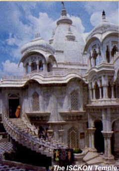
Vrindavan
Vrindavan, just 15 km from Mathura, is another major place of pilgrimage. It is noted for its numerous temples - both old and modern. The name Vrindavan evokes the playfulness and lovable characteristics of Shri Krishna. This is the wood where he frolicked with the gopis
and tenderly wooed Radha.
Vrindavan today, is noted for its numerous temples. The most important are :
The Madan Mohan Temple located near the Kali Ghat which was built by Kapur Ram Das of Multan. This is the oldest existent temple in Vrindavan today. The temple is closely associated with the saint Chaitanya. The original idol of Lord Madan Gopal was shifted from the shrine to Karauli in Rajasthan for safe keeping, during Aurangzeb's rule. Today, replica of the image is worshipped at the temple.
The Banke Bihari Temple built in 1864 is the most popular shrine at Vrindavan. The image of Banke Bihari was discovered in Nidhi Vana by Swami Haridas Ji, the great Krishna devotee, belonging to the Nimbarka sect.
The famous Radha Vallab Temple set up by the Radha-Vallab sect, has the crown of Radha-Rani placed next to the Shri Krishna idol in the sanctum.
The Jaipur Temple which was built by Sawai Madhav Singh, the Maharaja of Jaipur in 1917, is a richly embellished and opulent temple. The fine hand - carved sandstone is of unparalleled workmanship. The temple is dedicated to Shri Radha-Madhav.
The Shahji Temple, another popular temple at Vrindavan, was designed and built in 1876 by a wealthy jeweller, Shah Kundan Lal of Lucknow. The deities at the temple are popularly known as the Chhote Radha Raman.
Noted for its magnificent architecture and beautiful marble sculpture, the temple has twelve spiral columns each 15 feet high. The 'Basanti Kamra' - the darbar hall is famed for its Belgian glass chandeliers and fine paintings.
The Rangaji Temple, built in 1851, is dedicated to Lord Ranganatha or Rangaji depicted as Lord 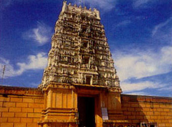 Vishnu in his Sheshashayi pose, resting on the coils of the sacred Shesha-nag. The temple built in the Dravidian style has a tall gopuram (gateway) of six storeys and a gold plated Dhwaja Stambha, 50 feet high. A water tank and a picturesque garden lie within the temple enclosure. The annual festival of Jal Vihar of the presiding deity is performed with great pomp and splendour at the tank. The temple is also famous for its 'Brahmotsav' celebration in March-April, more popularly known as the 'Rath ka Mela'. The ten day long celebrations are marked by the pulling of the rath (the chariot car) by the devotees from the temple to the adjoining gardens. Vishnu in his Sheshashayi pose, resting on the coils of the sacred Shesha-nag. The temple built in the Dravidian style has a tall gopuram (gateway) of six storeys and a gold plated Dhwaja Stambha, 50 feet high. A water tank and a picturesque garden lie within the temple enclosure. The annual festival of Jal Vihar of the presiding deity is performed with great pomp and splendour at the tank. The temple is also famous for its 'Brahmotsav' celebration in March-April, more popularly known as the 'Rath ka Mela'. The ten day long celebrations are marked by the pulling of the rath (the chariot car) by the devotees from the temple to the adjoining gardens.
The Govind Deo Temple was once a magnificent seven storeyed structure built in the form of a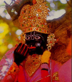 Greek cross. It is said that the Emperor Akbar donated some of the red sandstone that had been brought for the Red Fort at Agra, for the construction of this temple. Built at the astronomical cost of one Crore rupees in 1590 by his general Man Singh, the temple combines western, Hindu and Muslim architectural elements in its structure. Greek cross. It is said that the Emperor Akbar donated some of the red sandstone that had been brought for the Red Fort at Agra, for the construction of this temple. Built at the astronomical cost of one Crore rupees in 1590 by his general Man Singh, the temple combines western, Hindu and Muslim architectural elements in its structure.
The Shri Krishna-Balram Temple built by the International Society for Shri Krishna Consciousness (ISKCON), is one the most beautiful temples in Vrindavan today. The principal deities of this temple are Shri Krishna - Balram and Shri
Radha - Shyam Sundar. Adjoining the temple is the samadhi of Shri Prabhupada, the founder of the ISKCON sect, built in pure white marble.
Other places of interest include the Sriji Temple, Jugal Kishore Temple, Kesi Ghat, Lal Babu Temple, Raj Ghat, Meera Bai Temple, Imli Tal, Kaliya Ghat, Raman Reti, Varah Ghat and Chir Ghat.
The Seva Kunj is where Lord Krishna once performed the Raaslila with Radha Rani and the Gopis and Nidhi Van where the divine couple rested. The samadhi of Swami Haridasji is situated here.
The Sri Radha Shyam Sundar Temple situated at Parikrama Marg, Vrindavan, was built by Sri Anand Swaroop Kela in 2001. The principal deities of this temple are Sri Radha Shyam Sundar Ji, Sri Ved Bhagwan Ji, Sri Agam Bhagwa and Sri Gopeshwar Mahadev
Population : 56,692 (2001 Census)
Area : 2.25 sq. km.
Vrindavan is connected to Mathura and all other places of Braj by rail and bus services.
•International Rest House, Shri Krishna-Balram Temple, Raman Reti, Ph : (0565)2442478
•Jaipuria Smriti Bhavan, Govardhan Darwaza, Ph : 2442388
•Yatrika, Near Municipal Committee
•Jeevan Vallabh Yatri Niwas, Biharipura
•More Bhavan, Govardhan Darwaza
•Manorama Goyanka Guest House, Ph : (0565)2442493
•Geet Govind Tourist Complex, Nandanvan, Ph : (0565)2442517
•Sri Ram Vishanti Grah, Ph : (0565)2442833
•Govind Mohan Guest House, Ph : (0565)2442456
•Meera Mohan Guest House, Ph ; (0565)2442233
•Bharati Guest House
•Sri Banke Bihari Guest House, Ph : (0565)2443529, 2443530
•Dharmashalas : In Vrindavan there are nearly 200 dharmashalas, many of which are run by trusts.
•Shubham Guest House, Vidyapeeth Chauraha, Ph : 2443011, 2456025
•Sriji Palace Guest House, Chatikara Marg, Ph : 2540864
•MVT Guest House, Ramanreti Marg, Ph : 2540050
•Balaji Ashram, Ramanreti Marg, Ph : 2540424
•Sri Krishna-Balram Guest House, Ramanreti Marg, Ph : 2540021
•Agrasen Ashram, Parikrama Marg, Ph : 2540186
•Sri Radhey Shyam Ashram, Parikrama Marg, Ph : 2540197
•Sri Anand Dham, Parikrama Marg, Ph : 2340849, 2540414
•Sri Dhanuka Ashram, Parikrama Marg, Ph : 2540075
Lyrical expressions of Braj culture
Sanjhee :
This is the colourful art of decorating the ground with flowers. The story goes that Shri Krishna in order to please Radha, decorated the floor with flowers one evening and thereafter this art was known as Sanjhee.
Raaslila : According to the Bhagwat Purana, Shri Krishna along with the gopis had danced the Raas on the banks of the Yamuna at Vrindavan. When the gopis felt conceited about Lord Krishna dancing with them, he disappeared from their midst. In the agony of separation from the beloved Krishna, the gopis recalled and enacted his lilas (divine episodes of his life) which in course of time came to be known as the Raaslila. The Raaslila in its present form is ascribed to Swami Haridas and Shri Narayan Bhatt. Only young Brahmin boys of 13 to 14 years of age can perform the Raaslila. The charming childhood pranks of Shri Krishna constitute the main theme of these dramas.
Charkula :
This is a traditional folk dance of Braj, where a female dancer balances a column of lighted lamps over her head while dancing. The charkula, a tapered wooden column with four to five circular tiers has earthen lamps on each level. The number of lamps can range from 51 to 108 at times. The dancer with her face veiled, moves with swift, graceful movements while balancing the 40 to 50 kilogram charkula on her head. A dramatic dance that is visually attractive, it is performed on the Dooj of Holi, to the accompaniment of Rasiya songs rendered by the menfolk.
Rasiya :
This is the rich tradition of folk-songs that is found in the Braj area. Rasiya songs describe the love of the divine couple Radha and Shri Krishna. It is an inseparable part of the Holi celebrations and all other festive occasions at Braj. The Rasiya is sung to the rhythm of huge drums, locally known as bumb.
Agra : Once the capital of the Mughals and the city of the Taj Mahal, Agra is just 50 km from Matura. The Taj Mahal, a symphony in white marble, a tribute to eternal love, was built by the Emperor Shah Jahan in memory of his wife Mumtaz Mahal. Other splendid examples of Mughal architecture in Agra include the Agra Fort with its exquisite Pearl Mosque, palaces and darbar halls; the imposing mausoleum of Emperor Akbar at Sikandra, built in an amalgam of Hindu and Muslim architectural styles and Itmad-ud-Daula's tomb, embellished with coloured stone inlay and filigree marble screens.
Fatehpur Sikri :
(60 km from Mathura) The wonderful city of Fatehpur Sikri was built by the Emperor Akbar. The marvellously preserved fort, palaces and the tomb of Salim Chishti with its delicate lacy marble screens are worth seeing.
Varanasi is one of the oldest living cities in the world. Many names have been given to Varanasi, though its recently 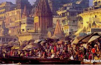 revived official appellation is mentioned in the Mahabharata and in the Jataka tales of Buddhism. It probably derives from the two rivers that flank the city, the Varuna to the north and the Asi to the south.. Many still use the anglicized forms of Banaras or Benares, while pilgrims refer to Kashi, first used three thousand years ago to describe the kingdom and the city outside which the Buddha preached his first sermon; the "City of Light" is also called Kashika, "the shining one", referring to the light of Shiva. Another epithet, Avimukta, meaning "Never Forsaken", refers to the city that Shiva never deserted, or that one should never leave. Further alternatives include Anandavana, the "forest of bliss", and Rudravasa, the place where Shiva (Rudra) resides. revived official appellation is mentioned in the Mahabharata and in the Jataka tales of Buddhism. It probably derives from the two rivers that flank the city, the Varuna to the north and the Asi to the south.. Many still use the anglicized forms of Banaras or Benares, while pilgrims refer to Kashi, first used three thousand years ago to describe the kingdom and the city outside which the Buddha preached his first sermon; the "City of Light" is also called Kashika, "the shining one", referring to the light of Shiva. Another epithet, Avimukta, meaning "Never Forsaken", refers to the city that Shiva never deserted, or that one should never leave. Further alternatives include Anandavana, the "forest of bliss", and Rudravasa, the place where Shiva (Rudra) resides.
Varanasi’s associations with Shiva extend to the beginning of time: legends relate how, after his marriage to Parvati, Shiva left his Himalyan abode and came to reside in Kashi with all the gods in attendance. Temporarily banished during the rule of the great king Divodasa, Shiva sent Brahma and Vishnu as his emissaries, but ultimately returned to his rightful abode protected by his loyal attendants Kalabhairav and Dandapani. Over 350 gods and goddesses, including a protective ring of Ganeshaa form a mandala or sacred pattern with Shiva Vishwanatha at its centre.
Each name carries an additional meaning in terms of the sacred symbolism of the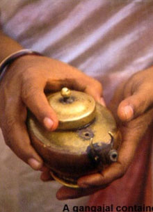 city, with each defining aprogressively decreasing arc starting and ending on the west bank of the Ganges. While the boundary of Kashi is delimited by the circular Panchakroshi Road, Varanasi is the main city, extending from Asi Ghat and circling around to the confluence of the Ganges and the Varuna. Yet a smaller area, defined as Avimukta, starts at Kedara Ghat in the south and ends at Trilochana Ghat. Most important of all is Antargriha, the "Inner Sanctum" around the Vishwanatha Temple, which encompasses Dashashwamedha Ghat, Surya Kund, the lingam of Bharabhuta, and Manikarnika Ghat. Another, later, interpretation suggests three sectors of khandas in the form of Shiva’s trident, each centered around a temple – Omkara to the north, Vishvanatha in the centre and Kendra to the south. city, with each defining aprogressively decreasing arc starting and ending on the west bank of the Ganges. While the boundary of Kashi is delimited by the circular Panchakroshi Road, Varanasi is the main city, extending from Asi Ghat and circling around to the confluence of the Ganges and the Varuna. Yet a smaller area, defined as Avimukta, starts at Kedara Ghat in the south and ends at Trilochana Ghat. Most important of all is Antargriha, the "Inner Sanctum" around the Vishwanatha Temple, which encompasses Dashashwamedha Ghat, Surya Kund, the lingam of Bharabhuta, and Manikarnika Ghat. Another, later, interpretation suggests three sectors of khandas in the form of Shiva’s trident, each centered around a temple – Omkara to the north, Vishvanatha in the centre and Kendra to the south.
A city which, since it is both an exalted place of pilgrimage and an idealize centre of faith, has been likened to Jerusalem and Mecca.According to the historians, the city was founded some ten centuries before the birth of Christ. The city is mentioned in Holy Scriptures like 'Vamana Purana', Buddhist texts and in the epic 'Mahabharata'.Mark Twain,the English author and litterateur,who was enthralled by the legend and sanctity of Banaras,once wrote:"Banaras is older than history,older than tradition,older even than legend and looks twice as old as all of them put together."Varanasi's prominence in Hindu mythology is virtually unrivalled. For the devout Hindu the city has always had a special place, besides being a pilgrimage centre,it is considered especially auspicious to die here, ensuring an instant route to heaven.The revered and ancient city Varanasi is the religious centre of the world of Hindus. A city where the past and present, eternity and continuity co-exist.
The city of Banaras is situated on the west bank of the holiest of all Indian rivers, the Ganga or Ganges. The relationship between the sacred river and the city is the essence of Varanasi - 'the land of sacred light'. The Ganga is believed to have flown from heave 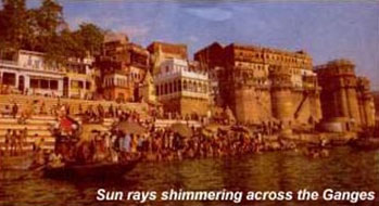 n to wash away the worldly sins of the human race.of mortal's .The life and activities in the city centre around the holy river. Life on the banks of the Ganga begins before dawn when thousands of pilgrims - men, women and children - come down to the river to wait for the rising sun when immersion in the sacred river will cleanse them of their sufferings and wash their sins away. n to wash away the worldly sins of the human race.of mortal's .The life and activities in the city centre around the holy river. Life on the banks of the Ganga begins before dawn when thousands of pilgrims - men, women and children - come down to the river to wait for the rising sun when immersion in the sacred river will cleanse them of their sufferings and wash their sins away.
Along the water's edge, there are the burning ghats. The most sacred one is Manikarnika, associated with Goddess Parvati, Lord Shiva's wife. The major shrine is the Vishwanath Temple the abode of Lord Shiva, the most important of the trinity, Brahma, Vishnu and Maheshwara, the Lords of this universe. Around this temple evolved the spiritual identity of Varanasi .The holy city within Banaras is thus called, Kashi, the luminous one or the city of the light.
It is beside the holy waters of the Ganga that the activities for which Banaras is held sacred are performed. Everyday thousands of residents and pilgrims bathe, offer prayers to the elements, to the rising sun, and to their dead ancestors who have been carried away by these waters. What draws people to the river is an ingrained belief that these waters can absolve the sins of many generations.
Everyone has their own way of celebrating the ritual contact with the holy Ganga: some bathe; other dip themselves entirely into the water once, thrice or any number of times; some drink the water; other  make water offerings to the sun; while others fill their pots with holy water to take back to their homes to perform rituals and purification.The offerings to the sacred waters vary. Pilgrims give flowers, fruits, lamps and their respectful prayers. On festival days and religious occasions the riverside is thick with their colorful bobbing up and down on the waters. make water offerings to the sun; while others fill their pots with holy water to take back to their homes to perform rituals and purification.The offerings to the sacred waters vary. Pilgrims give flowers, fruits, lamps and their respectful prayers. On festival days and religious occasions the riverside is thick with their colorful bobbing up and down on the waters.
The land around Banaras is also held sacred since Shiva is believed to have lived
here.There are thousands of temples at Benaras dedicated to different gods and goddesses, particularly to the deities of good fortune and prosperity-and to the sun and the planets. The most important are those that honor the diverse manifestations and attributes of Shiva.The major shrine at Banaras is the Vishvanatha Temple, devoted to Shiva, the Lord of the Universe.
The appearance of the pillar of light is said to have occurred at the site of Vishvanatha Temple. The holy city within Banaras is thus called Kashi "The Luminous One' or the 'City of Light'. Light in Hindu philosophy has great meaning for it exemplifies the wisdom that destroys the darkness of ignorance. Sin and evil are understood to be the acts of ignorance. When wisdom is acquired, evil will disappear. Sin cannot be washed away by water or prayer but only by 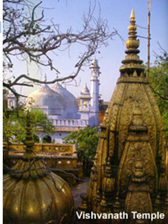 wisdom. Immorality is also reached through wisdom and understanding. So the City of Light is the City of Eternal Wisdom as well. To die in the city beside the river of life is to die with a promise of redemption, a promise to be liberated from the endless cycle of life and death and reincarnation, and to gain moksha or eternal absolution. So for centuries thousands of people have come to Banaras to die and thousands have brought the ashes of the dead here to immerse them in the holy waters. wisdom. Immorality is also reached through wisdom and understanding. So the City of Light is the City of Eternal Wisdom as well. To die in the city beside the river of life is to die with a promise of redemption, a promise to be liberated from the endless cycle of life and death and reincarnation, and to gain moksha or eternal absolution. So for centuries thousands of people have come to Banaras to die and thousands have brought the ashes of the dead here to immerse them in the holy waters.
Banaras has always been associated with philosophy and wisdom. A place of learning for many years, the Banaras Hindu University carries on this tradition. The University campus, to the south of the city, was built at the beginning of this century. Pundit Madan Mohan Malviya was instrumental in founding it. On campus is the Bharat Kala Bhavan Museum, which originated from the private collection of Rai Krishnadasa.
The Banaras region was administered by Hindu rulers for several hundred years until the 17th century, when it fell into the hands of the Mughals. As was the practice many buildings of the previous rulers and the religious structures of the Hindu and Buddhists were demolished during the wars of the conquest.
In Banaras we find many places where a temple once stood and where now mosque or some other structure stands. However, there is a little known farman, or royal decree, in the Bharat Kala Bhavan museum, which claims that Aurangzeb, the last great Mughal ruler, ordered his administrators to abstain from destroying any more temples. In succeeding years as Banaras continued to grow, the temples that were destroyed, were rebuilt or relocated.
Since Banaras is a pilgrimage centre, revered and honored throughout India,
pilgrims come from all parts of the country to visit it. Some travel 2,000 kilometers to bathe in the Ganga and to honor their dead. Earlier pilgrims used to walk to Banaras on foot, and along the way visited other pilgrimages.The antiquity of Banaras is known not just by the archeological remains but by the diverse and varied literature of India
The inflow of pilgrims developed Banaras as a trade centre. Besides traders, crafts people also settled in Banaras. Today the city is renowned for its silk weavers, who prepare the finest types of woven silk fabrics. A Banaras silk sari or shawl is traditionally a single colored textile with motifs and patterns woven in gold or silver threads. The technique is intricate, the procedure complex and demands great expertise .As the warp and the weft are interwoven on the loom, small ,often minute shuttles with gold thread are introduced to form the motif. When the design of the motif is completed, a knot is made and the gold thread cut. The weaving continues until the next design. The smaller the motif or the more intricate the design, the more complex the weaving skills required.
Silk weaving in Banaras is a cottage industry and in many areas of the city, especially the Muslim quarters, one can see looms at work all day . Entire families are involved, Children often pick up the art from the elders at an early age. There are shops in Banaras, and throughout India, that sell these fine silk fabrics
Area: 73.89 sq. km.
Population : 3147927 (As per 2001 census)
Altitude : 80.71 mtrs. above sea level
Temperature : Summer 32°C - 43°C ; Winter 5°C - 15.5°C
Season: October – March
Clothing: Summer - Cottons; Winters - Woolens
Rainfall : 111 cms annually ( approx )
Language: Hindi, English & Bhojpuri
Festivals: Shivratri, Dussehra, Ganga Festival, Bharat Milap, Dhrupad Mela, Hanumat Jayanti, Nakkatyya Chetganj, Nag Nathaiya Panch Kroshi Parikrama.
Local Transport : Buses, Cycle-rickshaws, Auto-rickshaws
STD Code : 0542
Air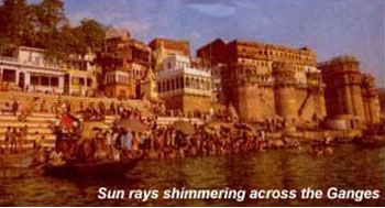
The nearest airport is Babatpur, 22 km from Varanasi and 30 Km from Sarnath. Direct flights for Varanasi are available from Delhi, Agra, Khajurao, Calcutta, Mumbai, Lucknow and Bhuvaneshwar and Kathmandu ( Nepal).
Rail
Varanasi and Mughal Sarai (one of the main railwa y stations of Varanasi) are the important rail junctions, with train connections to all major cities of India. Some important trains are: Rajdhani Exp (Hawrah-Mughal Sarai - New Delhi); Toofan Exp (Howrah-Mughal Sarai - Delhi); North East Superfast Exp (Delhi-Mughal Sarai Guwahati) Magadh Exp (Delhi-Mughal Sarai Patna); Mahanagari Exp (Varanasi-Mumbai); Pawan Exp (Muzaffarpur/ Darbhanga-Mumbai); Sabarmati Exp (Varanasi - Ahmedabad); Ganga Kaveri Exp (Chhapra - Chennai); Poorwa Exp (Howrah - Varanasi - Delhi) Himgiri Exp (Jammu-Varanasi - Howrah) ; Sealdah Exp (Varanasi - Jammu Tawi).
Road
Varanasi, on NH 2 from Calcutta to Delhi, NH 7 to Kanya Kumari and NH 29 to Gorakhpur is well connected to the rest of the country by good motorable roads. some of the major road distances are : Agra - 565 km, Allahabad - 128 km, Bhopal - 791 km, Bodhgaya - 240 km, Kanpur - 330 km, Khajuraho - 405 km, Lucknow - 286, Patna - 246 km, Sarnath - 10 Km.
The great river banks at Varanasi, built high with eighteenth and nineteenth-century pavilions and palaces, temples and terraces, are lined with an endless chain of stone steps – the ghats – progressing along the whole of the waterfront, altering in appearance with the dramatic seasonal fluctuations of the river level. Each of the hundred ghats, big and small, is marked by a lingam, and occupies its own special place in the religious geography of the city. Some have crumbled over the years, others continue to thrive, with early-morning bathers, brahmin priests offering puja, and people practicing meditation and yoga. Hindus puja, and people practicing meditation and yoga. Hindus regard the Ganges as amrita, the elixir of life, which brings purity to the living and salvation to the dead; sceptical outsiders tend to focus on all-persuasive and extreme lack of hygiene. Ashes to the dead, emissions from open drains and the left-overs from religious rites float by the devout as they go about their bathing and ceremonial cleansing.
For centuries, pilgrims have traced the perimeter of the city by a ritual circumambulation , paying homage to shrines on the way. Among the most popular routes is the Panchatirthi Yatra, which takes in the Pancha, (five) Trithi (crossing) of Asi, Dashashwamedha, Adi Keshva, Panchganga and finally Manikarnika. To gain merit or appease the gods, the devotee, accompanied by a panda (priest), recites a sankalpa (statement of intent) and performs a ritual at each stage of the journey. For the casual visitor, however the easiest way to see the is to follow a south-north sequence either by boat or on foot.
Asi Ghat to Kedara Ghat
At the clay-banked Asi Ghat, the southernmost in the sacred city, at the confluence of the Asi and the Ganges, pilgrims bathe prior to worshipping at a huge lingam under a peepal tree. Another lingam visited is that of Asisangameshvara, the "Lord of the Confluence of the Asi", in a small marble temple just off the ghat. Traditionally, pilgrims continued to Lolarka Kund, the Trembling Sun", a rectangular tank fifteen metres blow ground level, approached by steep steps. Now almost abandoned, except during the Lolarka Mela fair (Aug/Sept), when thousands come to propitiate the gods and pray for the birth of a son, Lolarka Kund is among Varanasi’s earliest sites, one of only two remaining Sun sites linked with the origins of Hinduism. Equated with the twelve adityas or divisions of the sun, which predate the great deities of Modern Hinduism, it was attracting bathers in the days of the buddha.
Much of the adjacent Tulsi Ghat – originally Lolarka Ghat, but renamed in the honour of the poet Tulsidas, who lived nearby in the sixteenth century – has crumbled. Continuing north, above Shivala Ghat, hanuman Ghat is the site of a new temple built by the ghat’s large south Indian community. Considered by many to be the birth place of the fifteenth-century Vaishnavite saint Vallabha, who was instrumental in in the resurgence of the worship of Krishna, the ghat also features a striking image of Ruru, the dog Bhairava, a ferocious and early form of Shiva.
Named for a legendary king said to have almost lost everything in a fit of self-abnegation, Harishchandra Ghat, one of the Varanasi’s two cremation of burning ghats, is easily recognizable from the smoke of its funeral pyres.
Further north, the busy Kendra Ghat is ignored by pilgrims on the Panchatirthi Yatra. Above its steps, a red-and-white-striped temple houses the Kedareshvara lingam, an outcrop of black rock shot through with a vein of white. Mythologically related to Kedarnath in the Himalayas, Kedara and its ghat become a hive of activity during the sacred month of Sravana (July/Aug), the month of the rains.
Chauki Ghat to chausathi Ghat
Northwards along the river, Chauki Ghat is distinguished by an enormous tree that shelters small stones shrines to the nagas, water-snake deities, while at the unmistakable Dhobi (Laundrymen’s) Ghat clothes are still rhythmically pulverized in the pursuit of purity. Past smaller ghats such as Mansarovar Ghat, named after the holy lake in Tibet, and Narada Ghat, honouring the divine musician and sage, lies Chausathi Ghat, where impressive stone steps lead up to the small temple of the Chausathi (64) Yoginis. Images of Kali and Durga in its inner sanctum represent a stage in the emergence of the great goddess as a single representation of a number of female divinities. Overlooking the ghats here is Peshwa Amrit Rao’s majestic sandstone haveli (mansion), built in 1807 and currently used for religious ceremonies and occasionally, as an auditorium for concerts.
Dashashwamedha Ghat
Dashashwamedha Ghat, the second and business of the five tirthas on the Panchatirthi Yatra, lies past the plain, flat-roofed building that houses the shrine of Shitala. Extremely popular, even in the rainy season when devotees have to wade to the temple or take a boat, Shitala represents both both benign and malevolent aspects – ease and succour as well as disease, particularly smallpox.
Dashashwamedha is Varanasi’s most popular and accessible bathing ghat, with rows of pandas sitting on wooden platforms under bamboo umbrellas, masseurs plying their trade and boatmen jostling for custom. Its name, "ten horse sacrifices", derives from a complex series of sacrifices performed by Brahma to test King Divodasa: Shiva and Parvati were sure the king’s resolve would fail, and he would be compelled to leave Kashi, thereby allowing them to return to their city. However, the sacrifices were so perfect that Brahma established the Brahmeshvara lingam here. Since that time, Dashashwamedha has become one of the most celebrated tirthas on earth, where pilgrims can reap the benefits of the huge sacrifice merely by bathing.
Man Mandir Ghat to Lalita Ghat
Man Mandir Ghat is known primarily for its magnificent eighteenth-century observatory, equipped with ornate window casings, and built for the Maharajah of Jaipur. Pilgrims pay homage to the important lingam of Someshvara, the lord of the moon, alongside, before crossing Tripurabhairavi Ghat to Mir Ghat and the New Vishwanatha Temple, built by conservative brahmins who claimed that the main Vishwanatha lingam was rendered impure when Harijans (untouchables) entered the sanctum in 1956. Mir Ghat also has a shrine to Vaishalakshi, the Wide-Eyed Goddess, on an important pitha – a site marking the place where various parts of the disintegrating body of Shakti fell as it was carried by the grief-stricken Shiva. Also here is the Dharma Kupa, the Well of Dharma, surrounded by subsidiary shrines and the lingam over all the dead of the world – except here in Varanasi.
Immediately to the north is Lalita Ghat, renowned for its ganga Keshava shrine to Vishnu and the Nepali Temple, a typical Kathmandu-style wooden temple which houses an image of Pashupateshvara – Shiva’s manifestation at Pashupatinath, in the Mathmandu Valley – and sports a small selection of erotic carvings.
Manikarnika Ghat
North of Lalita lies Varanasi’s pre-eminent cremation ground, Manikarnika Ghat.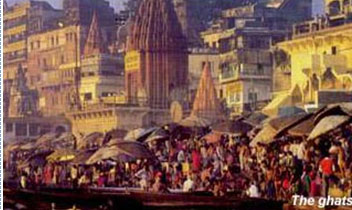 Such grounds are usually held to be inauspicious, and located on the fringes of cities, but the entire city of Shiva is regarded as Mahashmashana, the Great Cremation Ground for the corpse of the entire universe. The ghat is perpetually crowded with funeral parties, as well as the Doms, its Untouchable guardians, busy and pre-occupied with facilitating final release for those lucky enough to pass away here. Seeing bodies being cremated so publicly has always exerted a great fascination for visitors to the city, but photography is strictly taboo; even having a camera visible may be constructed as intent, and provoke hostility. Such grounds are usually held to be inauspicious, and located on the fringes of cities, but the entire city of Shiva is regarded as Mahashmashana, the Great Cremation Ground for the corpse of the entire universe. The ghat is perpetually crowded with funeral parties, as well as the Doms, its Untouchable guardians, busy and pre-occupied with facilitating final release for those lucky enough to pass away here. Seeing bodies being cremated so publicly has always exerted a great fascination for visitors to the city, but photography is strictly taboo; even having a camera visible may be constructed as intent, and provoke hostility.
Lying at the centre of the five tirthas, manikarnika Ghat symbolizes both creation and destruction, epitomized by the juxtaposition of the sacred well of Manikarnika Kund, said to have been dug by Vishnu at the time of creation, and the hot, sandy ash-infused soil of cremation grounds where time comes to an end. In Hindu mythology, Manikarnika Kund predates the arrival of the Ganga and has its source deep in the Himalayas. Vishnu cared the kund with his discus, and filled it with perspiration from his exertions in creating the world, at the behest of Shiva. When Shiva quivered with delighted, his earning fell into this pool, which as manikarnika – "Jewelled Earring" – became the first tirthas in the world. Every yea, after the floodwaters of the river have receded to leave the pool caked in alluvial deposits, the kund is re-dug. Its surroundings are cleaned and painted with brightly coloured folk art, which depicts the presiding goddess, Manikarnika Devi, inviting pilgrims to bathe and worship at its small Vishnu shrine, and at the paduka (footprint) of Vishnu set in marble on the embankment of the ghat. The most important of the lingams is the remains of Tarakeshvara, Shiva as Lord of Taraka mantra, a "prayer of the crossing" recited at death.
Strictly speaking, Manikarnika is the name given to the kund and to the ghat, while the constantly busy cremation ground is Jalasi Ghat, dominated by a dark smoke-stained temple built by Queen Ahalya Bai Holkar of Indore in the eighteenth century.
Scindia Ghat
Bordering Manikarnika to the north is the picturesque Scindia Ghat, with its titled Shiva temple lying partially submerged in the river, having fallen in as a result of the sheer weight of the ghat’s construction around 150 years ago. Above the ghat, several of Kashi’s most influential shrines are hidden within the tight maze of alleyways of the area known as Siddha Kshetra (the field of Fulfilment). Vireshvara, the Lord of all Heroes, is especially propitiated in prayer for a son; the Lord of Fire, Agni, was supposed to have been born here.
Panchganga Ghat to Adi Keshva Ghat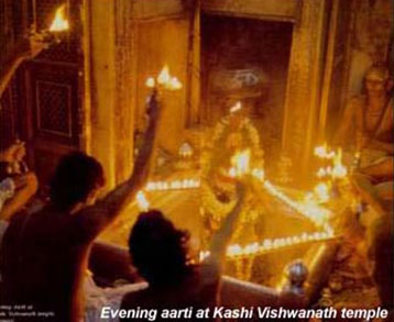
Beyond Lakshmanbala Ghat, with its commanding views of the river. Lies one of the most dramatic and controversial ghats, Panchganga Ghat, dominated by Varanasi’s largest riverside building, the great mosque of Alamgir, known locally as Beni Madhav-ka-Darera. With its minarets now much shortened, the mosque stands on the ruins of what must have been one of the city’s greatest temples, Bindu Madhava, a huge Vishnu temple that extended from Panchganga to Rama Ghat before it was destroyed by Aurangzeb and replaced by an impressive mosque. Panchganga also bears testimony to more favourable Hindu-Muslim relations, being the site of the initiation of the medieval saint of the Sufi-Sant tradition, Kabir, the son of a humble Muslim weaver who is venerated by Hindus and Muslims alike. Along the river front lies a curious array of three-sided cells, submerged during the rainy season, some with lingams, others with images of Vishnu, and some empty and used for meditation or yoga. One of these is a shrine to the Five (panch) Rivers (ganga) which, according to legend, have their confluence here: the two symbolic rivulets of Dhutapapa (Cleansed of Sin) and the Kirana (Sun’s Ray), which join the mythical confluence of the Yamuna and the Yamuna and the Sarasvati with the Ganga.
Above Trilochana Ghat, further north, is the holy ancient lingam of the Three (tri) Eye (lochana) Shiva. Beyond it, the river bypasses some of Varanasi’s oldest precincts, now predominantly Muslim in character; the ghats themselves gradually become less impressive and are usually of the kaccha (clay-banked) variety.
At Adi Keshava Ghat (the "Original Vishnu"), on the outskirts of the city, the Varana flows into the Ganga. Unapproachable during the rainy season, when it is completely submerged, it marks the place where Vishnu first landed as an emissary of Shiva, and stands on the original site of the city before it spread southwards; around Adi Keshva are a number of Ganesha shrine.
Vishwanatha Khanda - the Old City at the heart of Varanasi, between Dashashwamedha Ghat and Godaulia to the south and west and Manikarnika Ghat on the river to the north, lies Vishwanatha Khanda, sometimes referred to as the Old City. The whole area rewards exploration, with numerous shrines and lingams tucked into every corner, and buzzing with the activity of pilgrims, pandas and stalls selling offerings to the faithful.
Approached through a maze of narrow alleys and the Vishwanatha Gali (or Lane), the temple complex of Vishwanatha or Visheshwara, the "Lord of All", is popularly known as the Golden Temple, due to the massive gold plating on its shikhara (spire). Inside the compound - which is hidden behind a wall, and entered through an unassuming doorway - is one of India's most important shivalingams, made of smooth black stone and seated in a solid silver plinth, as well as shrines to the wrathful protectors Mahakala and Dandapani, and the lingam of Avimukteshvara, the Lord of the Unforsaken, which predates Vishwanatha and once held much greater significance. The current temple was built in 1777 by Queen Ahalya Bai Holkar of Indore, and is closed to non-Hindus, who have to make do with glimpses from adjacent buildings.
Vishwanatha's history has been fraught Sacked by successive Muslim rulers, the temple was repeatedly rebuilt, until the grand edifice begun in 1585 by Todar Mal, a courtier of the tolerant Moghul Akbar, was finally destroyed by Aurangzeb. On its foundations, guarded by armed police to protect it from Hindu fanatics, stands the Jnana Vapi Mosque, also known as the Great Mosque of Aurangzeb. Its simple white domes tower over the Jnana Vapi (Wisdom Well), immediately north, housed in an open arcaded hall built in 1828, where Shiva cooled his lingam after the construction of Vishwanatha. Covered by a grate to prevent people jumping in, in search of instant moksha, and covered with a cloth to stop coins being thrown in, only the presiding brahmins have access to its waters, considered to be liquid knowledge.
Pilgrims offer their sankalpa or statement of intent here, before commencing the Panchatirthi Yatra. Slightly north, across the main road, the thirteenth-century Razia's Mosque stands atop the ruins of a still earlier Vishwanatha temple, destroyed under the Sultanate.
Close by, the temple of Annapurna Bhavani is dedicated to the supreme Shakti ("She, the Being of Plenteous Food"), the queen and divine mother also known in this benevolent form as Mother of the Three Worlds. As the provider of sustenance, she carries a cooking pot rather than the fearsome weapons borne by her horrific forms Durga and Kali a subsidiary shrine opened only three days a year houses a solid gold image of Annapurna. Nearby is a stunning image, faced in silver against a black surround, of Shani or Saturn. Anyone whose fortunes fall under his shadow is stricken with bad luck - a fate devotees try to escape by worshipping here on Saturdays.
The Kashi Vishwanath Temple
Also known as the Golden Temple, it is dedicated to Lord Shiva, the presiding deity of the city. Varanasi is said to be the point at which the first jyotirlinga, the fiery pillar of light by which Shiva manifested his supremacy over other gods, broke through the earth’s crust and flared towards the heavens. More than the Ghats and even the Ganga, the Shivalinga installed in the temple remains the devotional focus of Varanasi. Entry restricted for foreigners.
|